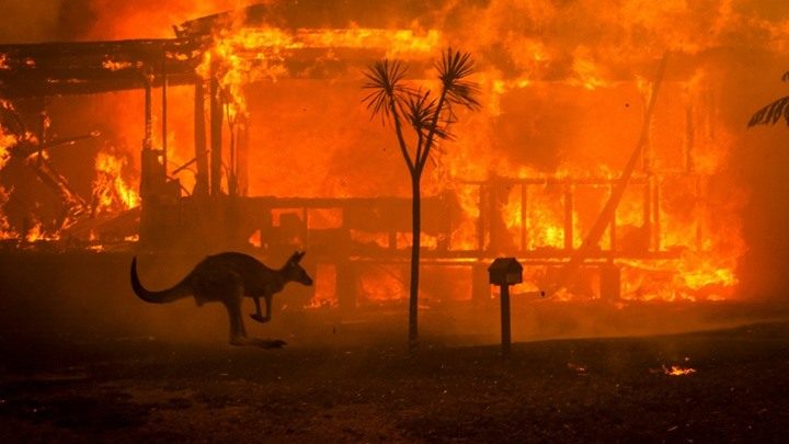
تعيش أستراليا حالياً أوقاتاً لا تحسد عليها، فالحرائق تنتشر في 4 ولايات بالبلاد، وتمتد جبهاتها لمئات الكيلومترات، بفعل العواصف الرعدية وارتفاع درجات الحرارة، والرياح القوية.
وتعد العواصف الرعدية أحد الأسباب الرئيسية لاندلاع الحرائق بأستراليا سنوياً، ورغم أنها أمرٌ اعتاده الجميع، فإن الغريب في الموضوع أن دخان الحرائق نفسها يتسبب أيضاً بصنع عواصف رعدية جديدة وفق موقع Quartz.
When bushfires make their own weather, they generate ‘pyrocumulonimbus’ clouds and storms. These can cause dangerous and unpredictable changes in fire behaviour, making the fire more difficult and hazardous to fight. This is how they form: 1. A plume of hot, turbulent air and smoke rises. 2. Turbulence mixes cooler air into the plume, causing it to broaden and cool as it rises. 3. When the plume rises high enough, low atmospheric pressure causes its air to cool and cloud to form. 4. In an unstable atmosphere a thunderstorm can develop: pyrocumulonimbus cloud 5. Rain in the cloud evaporates and cools when it comes into contact with dry air, producing a downburst. 6. Lightning may be produced and can ignite new fires. #bureauofmeteorology #pyrocumulonimbus #severeweather #vicfires #nswfires #ausfires #australianbushfires #instaweather #instascience #stormscience
A post shared by Bureau of Meteorology (@bureauofmeteorology) on Jan 2, 2020 at 12:35am PST
الكوارث الطبيعية الكبيرة مثل الحرائق، يمكنها أن تنشئ نظاماً جوياً خاصاً بها، مثلما يحدث الآن في أستراليا، إذ تصنع حرائق الغابات الأسترالية الشديدة عواصف رعدية.
كيف يحدث هذا؟ تتسبب حرائق الغابات في تسخين الهواء والرطوبة ورفعهما إلى الأعلى، ليلتقيا الهواء البارد في الجو بطبقة التروبوسفير، فيتحول هذا الهواء إلى غيوم تُعرف بــPyrocumulus «سحابة النار».
عندما تتشكل سحابة النار النادرة والخطيرة، تتحرك بسرعة في الجو، فتخلق عواصف رعدية قوية ورياحاً سريعة.
Exactly a week ago, a bushfire began in Forster, NSW, resulting in what you can see in this photo. Known as ‘pyrocumulonimbus’, these clouds can generate their own weather, causing dangerous and unpredictable changes in fire behaviour. So, how do they form? 1. A plume of hot, turbulent air and smoke rises. 2. Turbulence mixes cooler air into the plume, causing it to broaden and cool as it rises. 3. When the plume rises high enough, low atmospheric pressure causes its air to cool and a cloud to form. 4. In an unstable atmosphere a thunderstorm can develop: pyrocumulonimbus cloud. 5. Rain in the cloud evaporates and cools when it comes into contact with dry air, producing a downburst. 6. Lightning may be produced and can ignite new fires. For more info on this and other amazing science, check out our website. ? Daryl Lehmann #weatherphotography #pyrocumulonimbus #bureauofmeteorology #forster #nswfires #severeweather #cloudphotography
A post shared by Bureau of Meteorology (@bureauofmeteorology) on Nov 15, 2019 at 12:20am PST
بإمكان هذه العواصف الرعدية والرياح أن تصنعا حدثين في الغلاف الجوي: الانفجارات أو البرق.
الانفجارات: في حالة حدوث انفجار، يمكن أن تصل الرياح إلى سرعة 170 ميلاً في الساعة، أي نحو 270 كيلومتراً بالساعة؛ وهو ما يتسبب في إتلاف مساحات كبيرة من الغابات بسرعة قياسية.
البرق: يساعد في توسيع رقعة الحريق ونقله إلى مناطق جديدة من الغابات.
وتسببت حرائق الغابات بأستراليا إلى الآن في قتل عشرات الأشخاص، إضافة إلى نفوق نحو نصف مليار حيوان من الثدييات والطيور والزواحف، بينها ما يقرب من 8000 من حيوانات الكوالا النادرة، التي يُعتقد أنها احترقت حتى الموت على الساحل الشمالي لأستراليا، وهو ما يثير مخاوف من انقراض أنواع من الحيوانات.